US News
Hawaii Faces Worst Flooding in Two Decades as Dam Concerns Ease
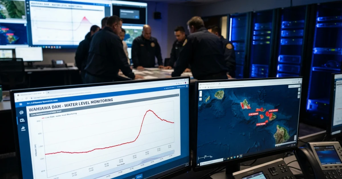
Hawaii is grappling with its most severe flooding in two decades, as relentless rainfall this week threatened the integrity of the Wahiawa Dam on Oahu, forced hundreds of residents to evacuate, and prompted authorities to keep a close watch on weather forecasts for further storms.
Evacuations and Emergency Response
Emergency officials ordered evacuations in areas around Waialua and Haleiwa on Oahu’s North Shore on Wednesday after water levels at Wahiawa Dam rose rapidly due to persistent rainfall. According to AP News, these evacuation orders were lifted late Thursday as dam levels stabilized and immediate risk subsided.
- Authorities cited the flooding as the worst Hawaii has experienced in 20 years.
- Evacuation centers were set up in nearby communities to shelter displaced residents.
- Local officials urged caution as additional rainfall was forecast, keeping first responders on high alert.
Dam Safety and Flood Risk
The Wahiawa Dam, a key structure regulating water flow on Oahu, became a focal point of concern as water levels rose to heights not seen in years. The state’s Department of Land and Natural Resources oversees the Hawaii Dam Safety Program, which includes rigorous inspection and emergency action protocols for structures like Wahiawa.
The 2019 Hawaii Dam Inventory lists Wahiawa as a regulated facility with a high hazard potential, meaning failure could result in significant downstream impact. AP News reported that water levels reached thresholds that triggered emergency guidelines but did not breach safety limits.
Officials continue to monitor real-time streamflow and water levels using data from the USGS Current Water Data for Hawaii, ensuring any further increases are met with rapid response.
Rainfall and Flooding Severity
Rain gauges across Oahu registered rainfall totals well above seasonal averages. According to the National Weather Service Honolulu’s Hydrology Summary, parts of the island saw several inches of rain within 24 hours, overwhelming streams and low-lying areas.
Floodwaters inundated roads, damaged properties, and led to power outages in affected neighborhoods. The National Weather Service forecast called for more showers over the weekend, raising concerns about saturated soils and the potential for renewed flash flooding.
- Flooding was most severe in northern and central Oahu.
- Several minor roadways and bridges remained closed as of Thursday evening.
- Historical rainfall records from NOAA Climate Data Online show the current event ranks among the most intense since the early 2000s.
Community Impact and Next Steps
While evacuation orders have been lifted, state and local agencies urged residents to remain vigilant. Emergency managers highlighted the ongoing risk of landslides and stream overflow, especially in areas where the ground remains saturated.
Homeowners and businesses have been advised to consult the FEMA Flood Map Service Center for up-to-date flood risk assessments. Flooding of this magnitude, according to a USGS investigation, is rare but can have lasting impacts on infrastructure and local economies.
Looking Ahead as More Rain Approaches
With more rain in the forecast, emergency responders remain on standby. The episode serves as a reminder of Hawaii’s vulnerability to extreme weather events and the importance of robust dam safety and flood management systems. Officials committed to ongoing inspections and updates to emergency plans as the situation develops.
Residents are encouraged to monitor official channels for the latest weather updates and evacuation guidance.