World
Satellite images reveal damage to Iran's missile, nuclear sites
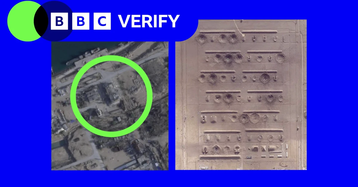
New satellite images from Esfahan and Bushehr showed strikes on ammunition storage areas, ballistic missile infrastructure, nuclear sites, surface-to-air missile sites and naval bases in Iran, even as commercial access to the war zone stayed tightly constrained. BBC Verify analyzed imagery captured after restrictions began on 9 March 2026, and military intelligence company Janes identified the damage across those categories.
The restriction deepened on 5 April, when Planet Labs said it would indefinitely withhold imagery of Iran and the broader Middle East conflict zone at the request of the U.S. government. The company said the policy would apply to imagery dating back to 9 March and that it would move to a managed, case-by-case release system for urgent or public-interest needs. Vantor, formerly Maxar Technologies, said it had not been contacted by the U.S. government, but it kept the right to impose enhanced access controls during geopolitical conflict and said it already had current restrictions in parts of the Middle East.
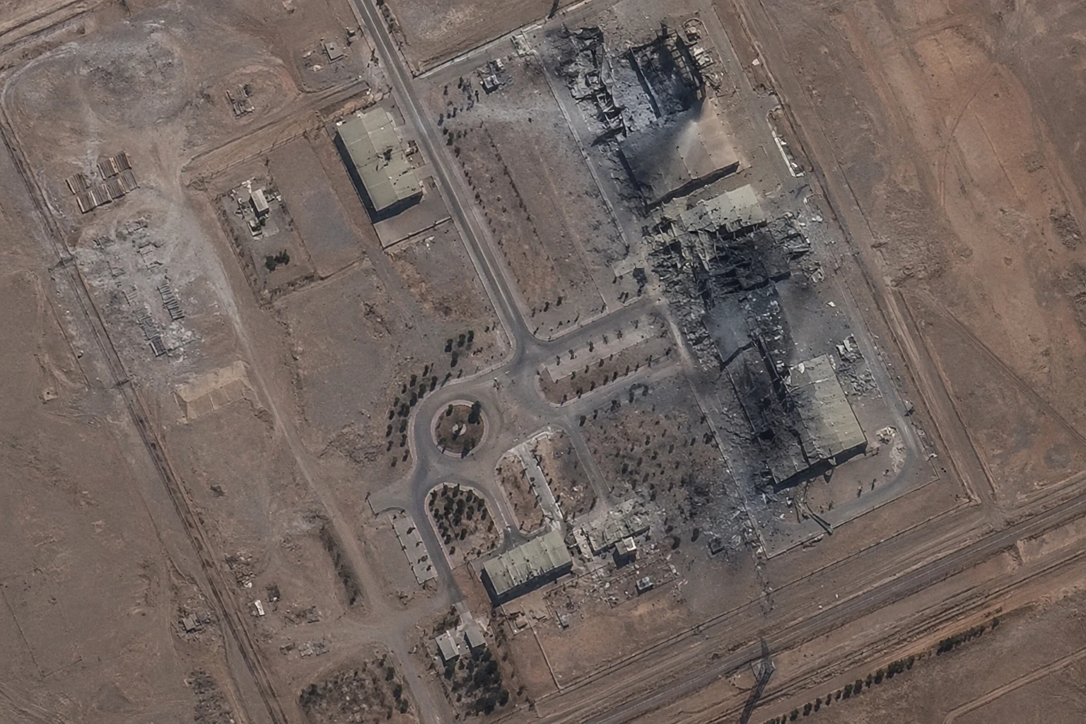
That narrowing matters because commercial satellite imagery has become one of the main ways journalists, governments and analysts verify damage in places that are difficult to reach on the ground. Carlos Gonzalez of Bellingcat has said timely imagery is essential for locating impacts and cross-checking eyewitness and other open-source evidence. The pictures can confirm that something was hit, where it was hit and how broadly a site was affected, but they cannot by themselves establish who fired the weapon, what happened underground or whether every part of a facility is still operational.
The images add to an expanding picture of a conflict that began when the United States and Israel attacked Iran on 28 February 2026. Iran responded with attacks on Israel and U.S. bases in Gulf states including Saudi Arabia, Kuwait and Bahrain. Separate satellite images from 9 March showed damage to naval bases, airports and other key facilities inside Iran, underscoring that the fighting had already moved beyond nuclear and missile targets into wider military infrastructure.
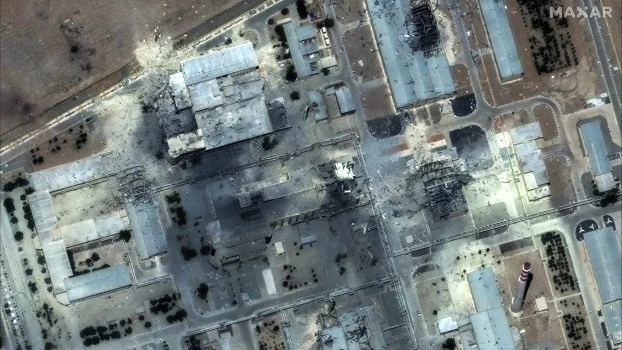
For policymakers, that distinction between visible damage and proven military effect is crucial. A burned storage area or shattered building can be confirmed from orbit; the state of buried systems, dispersed launchers and remaining capacity cannot. With commercial imagery more tightly rationed, each released frame now carries more weight in judging how much of Iran’s nuclear and missile network has actually been degraded.
Sources
- [1]bbc.co.uk
- [2]cnbc.com
- [3]gijn.org
- [4]cbc.ca
- [5]tahrir2day.com