US News
Severe Storms Sweep Central US, Threat Moves East
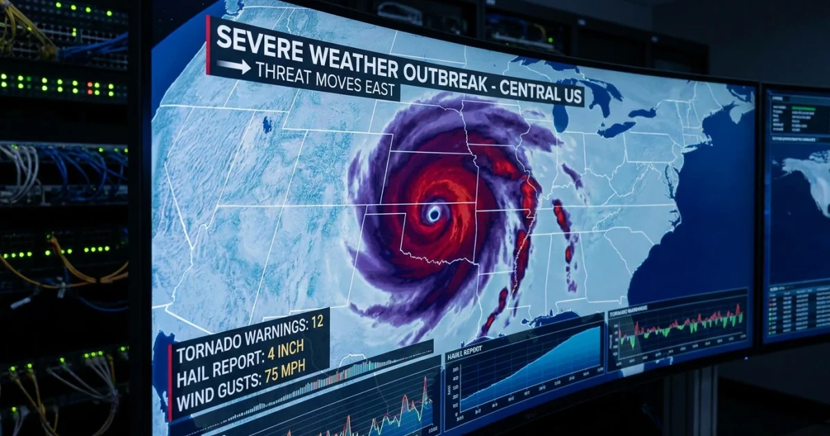
Severe storms erupted across the Central United States Monday night and into Tuesday, triggering widespread tornado, hail, and wind threats as the weather pattern pushes east, according to The Weather Channel's live outbreak tracker. The risk for dangerous weather will gradually diminish as the system moves into eastern regions, but authorities urge residents to stay alert for evolving warnings and watches.
Storm Outbreak Causes Significant Damage and Disruption
Communities from Kansas to Missouri and parts of Illinois experienced intense weather, including multiple reports of tornadoes, large hail, and damaging winds. Today's Storm Reports from the Storm Prediction Center detail dozens of severe weather incidents, including tornado touchdowns and hailstones exceeding two inches in diameter. Local emergency managers reported power outages, property damage, and downed trees in affected areas.
- Numerous tornado warnings were issued overnight, with National Weather Service warnings and watches covering large swathes of the Midwest.
- Storms produced hail up to 2.75 inches in diameter in some locations, according to live tracker maps.
- Wind gusts exceeded 70 mph, knocking out power and causing dangerous road conditions.
Risk Gradually Eases as Storms Move East
Forecasters from The Weather Channel noted that the severe threat will shift eastward on Tuesday, impacting states from Indiana to Ohio and Kentucky. The Storm Prediction Center's convective outlook places much of the eastern Midwest under a slight to enhanced risk for severe storms, though the intensity is expected to taper off as the system moves into less favorable conditions.
Residents in the path of the storms are advised to monitor local forecasts and heed any warnings, as the possibility of isolated tornadoes and strong winds remains. The Weather Channel’s tracker provides real-time radar updates, storm reports, and interactive maps to help communities stay informed.
Understanding Severe Weather Warnings
Severe weather warnings are issued when conditions are favorable for tornadoes, damaging winds, or large hail. The NOAA NSSL Severe Weather 101 guide explains how meteorologists assess storm risks and communicate hazards to the public. When a warning is announced, residents should immediately seek shelter and follow official guidance.
Historical data from the NOAA Storm Events Database reveals that May is often one of the most active months for tornadoes and severe storms in the US, particularly in the Midwest and Plains.
Staying Prepared as Storms Continue
Emergency officials and meteorologists stress the importance of preparedness during severe weather outbreaks. Key steps include:
- Monitoring local alerts and weather apps for real-time information
- Having a safety plan for sheltering during tornado warnings
- Securing outdoor items and avoiding travel during hazardous conditions
As the storms move east, the overall threat will decrease, but isolated severe events remain possible. Communities in the path should remain vigilant and review their preparedness plans.
For live updates, interactive maps, and official warnings, visit the National Weather Service warnings map and the Iowa State University NWS Watch/Warning Archive.
With severe weather season in full swing, experts emphasize community readiness and awareness as the best defense against sudden storms.